Nov-Dec 2011, Mojave Desert Bicycle Tour
All content copyright © 2010-2026 Frank Revelo, www.frankrevelo.com, United States copyright office registration number TX-7931345
Planning
Current guide to maps for a trip like this is here. This guide will be updated as time passes, and so may not reflect what I actually used on this trip, which was a combination of: (a) pages from the California Benchmark Road Atlas; (b) National Geographic topo paper maps for Death Valley National park and Mojave National Preserve; (c) Tom Harrison map for Mojave National Preserve; (d) Garmin Foretrex 301 non-mapping GPS to find myself on the paper maps occasionally; (e) offline Navteq road maps on my Nokia N8 smartphone.
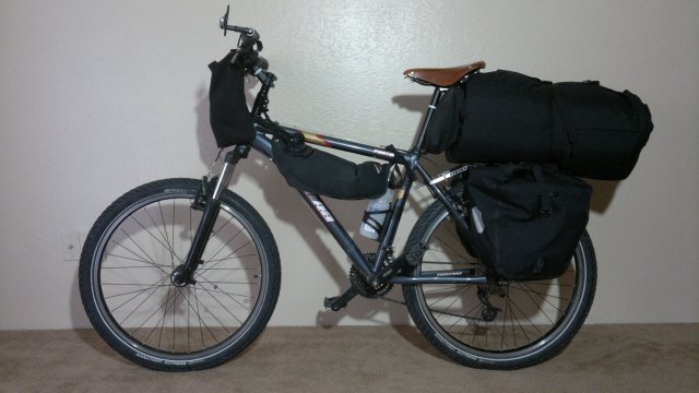
bike and gear that I used on this trip (details here)
Mon 21 Nov 2011
Took CREST bus from Reno to Lone Pine ($60). Racks on bus just wide enough for 2.25" (57-559) tires. Would be a problem with fatter tires. Checked into Dow Villa ($50 incl tax for room with shared bath down the hall).
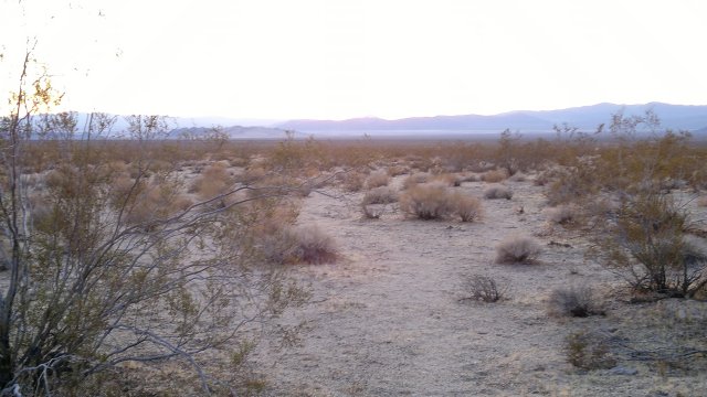
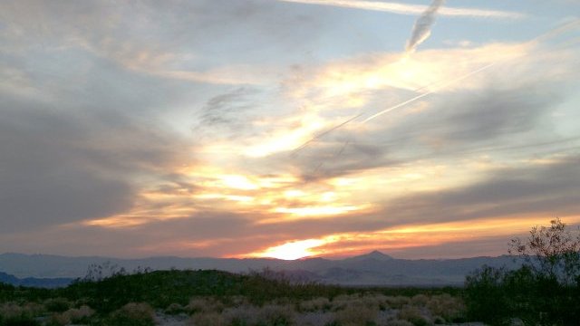
Tue, 22 Nov 2011 (40 miles, starting odometer 286)
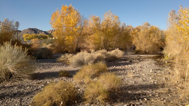
I was anxious to get onto dirt roads as soon as possible, so I rode north a mile or so and then took the Lone Pine Narrow Gauge Road (street sign and shown on road atlas map), then the Dolomite road, then Highway 136 until Saline Valley Road. Camped amidst Joshua trees before the Santa Rosa Wash, 5200' elevation. (Distances are from the bike computer. Thus I won't be counting miles of hiking, if any.)
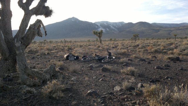
campsite near darwin plateau
Wed, 23 Nov 2011 (20 miles)
I slept with the bivy top closed and there was heavy condensation in the morning. Ice all over the top of the quilt. Ice in the water bottle as well. Bladders okay because I brought them into the bivy when I realized temperatures would drop below freezing. Having doubts about this bivy sack. If condensation is this bad without rain, what will it be like with rain?
Continued along Saline Valley Road. Had to push the bike at times, since I am not yet strong enough to pedal up steep hills, especially with the bike fully loaded (16 liters water and 13 lbs food). Raised the saddle, because it was too low. Ate some snow (patches 4" deep under bushes on Lee Flat) when I felt thirsty, because I wanted to conserve water. Later, encountered a stream running in Jackass Canyon and filled up there. Some parts of the road down Jackass canyon had 12" of snow, but this was powder and had been compressed to nothing by cars. About 20 cars passed me, all descending Jackass Canyon. The Thanksgiving holiday crowd.
Hiked for an hour up a side canyon towards springs marked on the National Geographic map (Big and Little Dodd springs) but couldn't find them, though I did encounter a clump of trees and bushes indicating water available underground. Maybe these are seasonal springs. This side expedition made me realize how much easier it is to hike than ride a heavily loaded bike. But the bike reigns supreme on flat stretches of paved road, where hiking is very demoralizing.
Camped near the side road (Lippincott road on the road atlas map) which leads from Saline valley to Racetrack valley. Campsite at 3400' elevation. Wild burro curious about me as I was setting up camp, but I chased it off. Starts to get dark about 5PM, so I'm stopping at 4PM and under my quilt by 5PM. Sunrise about 6AM. Based on my experience hiking, I will typically rise about 6AM and be on my way by 7AM. Thus 13 hours under the quilt, 9 hour of travel, not counting rest stops.
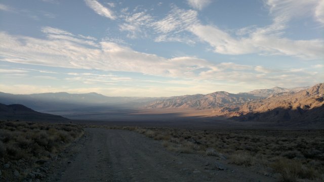
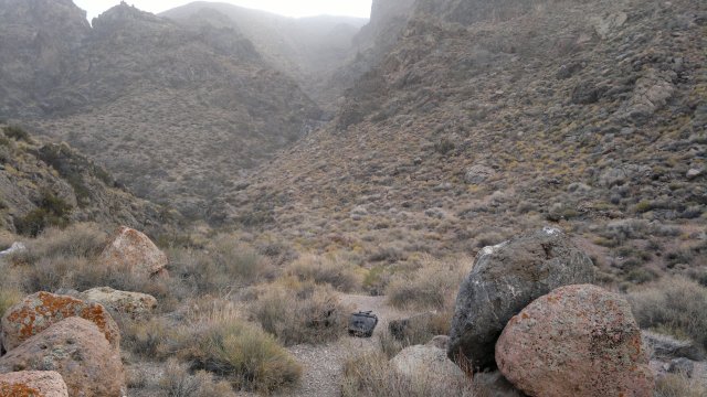
descent into saline valley
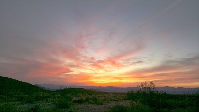
Thu, 24 Nov 2011 (20 miles)
Today is Thanksgiving. No condensation in bivy in morning. So maybe the design is okay after all.
Fell and hit my forehead on a rock while descending a particularly steep and rocky stretch of Lippincott Road. I was going very slow (in fact, that is why I fell, since the bike stalled) and my fur felt hat protected me, but the lesson is clear. I need to stop and walk the bike when conditions get particularly rugged. Also, I'm still adjusting to the higher saddle. I don't want to lower it back to where it was, because I need all the power I can get for ascending.
Grueling ascent to Lippincott Pass (pass between south end of Saline and Racetrack valleys). Had to push the bike the whole way. Steep and covered with big rocks. Multiple stops to rest my pounding heart and exhausted arm muscles. Note that I am fairly strong (I can do 15 pull-ups, for example) and carry lightweight gear. Weaker bikers, especially smaller middle-aged or older women with weak upper body strength, or anyone with heavyweight gear and the same amount of food and water as me, will likely find pushing a bike up this road impossible. Warning sign at the top: "Only for high-clearance 4-wheel-drive vehicles and experienced drivers, no towing service available". What happens if a jeep descending meets one ascending, since the road is too narrow to pass? The usual rule is that the jeep descending has to back up, since the ascending jeep might gain speed and lose control if it tried backing up. The thought of backing up on this road in a jeep makes me shudder.
Racetrack valley road is terribly washboarded. Nerve-wracking after a while. Talked to a guy photographing the moving rocks on the Racetrack. He's driving a big Land Rover, loaded to the gills with spare cans of gasoline and water, shovel, winch and other gear for extricating the vehicle from deep sand and other obstacles. Biking may be more complicated than hiking, but at least it is far simpler than traveling in a motorized vehicle in the backcountry. Turned at Teakettle Junction towards Hidden Valley and camped before Lost Burro Gap, at elevation 4500'.
Fri, 25 Nov 2011 (14 miles)
Slept with the bivy top closed again, even though there was no likelihood of rain or heavy dew. Not sure why. Maybe just a habit. The idea of wanting a dark cave to crawl into for sleeping. Bivy very loud when wind picked up. Furled the top and the noise disappeared. Need to get used to sleeping under the stars and only close the top when absolutely necessary. Temperature somewhere in the 40's. I think that first night was exceptional and I won't see freezing temperatures again for several weeks.
Pedaled and pushed the bike to Burro spring trail, then hid the bike behind a rock and hiked up the trail towards the spring, but no trace of water. Lots of 3" deep snow patches under the bushes, so I made snowballs and ate these to keep hydrated along the hike. Still 12 liters or so of water in my bladders, but I'm curious about the spring situation here. Also, searching for water is a good excuse for some hiking, which is far more pleasant than biking on these washboard gravel roads. Wide tires, with moderate air pressure, is a must for this sort of surface, especially for a bike without suspension. Felt quite tired today. Probably the after-effects of that struggle to get up Lippincott Road.
Camped behind a hill in Hidden Valley, elevation 4600'. Ground very sandy. Tent stakes would never hold. So a bivy is definitely the right choice. Or a standalone tent for those who aren't weight-conscious. I picked up two sticks in Jackass Canyon, but that may be the last trees I see for a while, so I'm using smooth rocks for wiping and saving the sticks for cases where there are neither sticks nor rocks, nothing but sand. I didn't treat the water in Jackass Canyon, incidentally, but it doesn't seem to have upset my stomach. I probably still have immunity from all the untreated water I drank along the PCT earlier this year.
Sat, 26 Nov 2011 (23 miles)
Slept with bivy top open for a change. Under the stars in other words. No condensation, no dew. Small amount of ice in bottle and bladders, so temperature evidently was just slightly under freezing.
Stashed the bike amidst the bushes and hiked up to Lost Burro mine. Interesting relics rusting away up there. Doesn't seem to be much growing in the desert, but still easy to hide the bike. If I didn't know where to look, I would never have noticed it from the road, even though it was only 50 feet away.
Roads very washboarded. Assuming I travel at 6 miles/hour and can tolerate maybe 5 hours/day of such roads, distance/day will be 30 miles. Not that I'm in a rush, but I do need to have some idea of how fast I will be moving, so as to plan my resupply stops. 30 miles/day is slightly more than my typical hiking distance of 24 miles/day. Biking on washboarded roads is more nerve-wracking than hiking such terrain, but biking takes less hours and is less physically tiring (other than for steep ascents). And the bike will prove its merits when I hit long stretches of flat paved road. So the best approach is to combine biking and hiking. That is, bike on the flats, then stash the bike and hike in the hills for a change of pace, which is what I did both today and yesterday.
Saw maybe 50 cars and trucks. All this traffic should be gone after Sunday, when the Thanksgiving holiday crowd goes back home. Camped about midway between Teakettle Junction and Ubehebe Crater, at elevation 4600'.
between teakettle junction and ubehebe crater
Sun, 27 Nov 2011 (57 miles)
An hour or so of the nerve-wracking washboard, then stopped off to view Ubehebe crater, then sped down the paved road to Stovepipe wells. Straight downhill all the way, 2500' of descent, very smooth road. First time I've ever ridden the bike on roads like this. Only a small number of cars early in the morning, and those passing me gave me plenty of space, so not really annoying. Skipped Scotty's castle because I wanted to get to Stovepipe Wells early enough to shower and wash my clothes. (I need warm sunshine to dry them, since I only have a single pair of clothes). Shower/swimming pool access was $4. Ate a lot of junk food at the store and bought some corn tortillas and cheese for the next few days of travel. I want to conserve my rice and peanuts, since these will be hard to replenish.
Camped amidst the sagebrush, near the Stovepipe Wells airport, at elevation 0 (sea-level).
Mon, 28 Nov 2011 (37 miles)
Long ride uphill (4000') to Beatty, along the Daylight Pass road. Pushed the bike part of the way. Pushing uphill is easier than riding uphill, I realized. Actually, anytime I can't keep the bike moving at least 5 miles/hour, it is easier to get off and push. Very few cars and they gave me wide berth, though their speed is still somewhat nerve-wracking. Partly cloudy skies.
Local guy asked what I was up to, then advised me to try the Atomic Inn aka Phoenix Inn, and so I did. $44 for a very nice room. Motel 6 had quoted $56 and I'm sure the rooms wouldn't be as nice. When I checked Phoenix Inn out on the internet (they have good wireless service), they had some bad reviews. I don't know why, because the room is very nice (especially for the price) and so are the owners. Maybe there has been a management change. Most of the bad reviews were from the summer months, I noticed. Maybe things get hectic and the managers can't provide good service then? Also one has to question the judgment of anyone visiting Death Valley in the summer.
Bought some travel food (bread, cheese and lettuce) at the little general store near the motel. Bread and cheese (but no fresh fruits or vegetables) also available at the gas station convenience store. And there is a small store at the RV park (didn't visit), and a nuts and candy store oriented towards tourists (didn't visit this either, though I probably should have, to get more dry-roasted peanuts).
Beatty is at elevation 4000'.
trees along amargosa river in beatty
Tue, 29 Nov 2011 (14 miles)
My legs were exhausted from yesterday's ascent, so I decided to stay another night in Beatty. I also have a case of mild bronchitis, probably from breathing the dry air while huffing and puffing uphill yesterday. Definitely should have pushed the bike once I got tired rather than continuing to pedal. Visited the ghost town of Rhyolite (about 6 miles away) and the local museum (very interesting). Weather forecast for strong north wind for the next two days, with slight possibility of rain. This will be a cross wind until I get to Titus Canyon, and from there I should be protected in the canyon, and then it will be a tailwind when I emerge from the canyon and head south.
Wed, 30 Nov 2011 (21 miles)
Bronchitis getting better. Flat rear tire on road to Titus Canyon. Removed tire and tube and inspected. A long thorn was embedded in the inside of the tire. Apparently, as the tire and tube moved against one another, this thorn kept re-opening the puncture in the tube, so that eventually all the sealant leaked out and the tire went flat. Pulled the thorn out, then fixed the puncture with a patch (first time I've done so with this bike), put some new sealant in the tube, reinflated and reinstalled. Need to bring more bottles of sealant for situations like this. 4 bottles at least, maybe 6. Oiled the chain and various other moving parts.
Wind picked up starting about 9AM, and became very strong at the day progressed. Pushed the bike up some steep ascents. I've learned my lesson: always dismount and push when the going gets tough. About 20 cars passed me. I had hoped things would have quieted down, now that Thanksgiving is past, but apparently Titus Canyon is a must-see. Stopped early (about 2PM) because wind was becoming ferocious and I wasn't sure if I would find shelter beyond what I had found then—namely, a side canyon with a big rock on one side of flat spot and bushes on all the other sides. Should be sufficient for the bivy sack, at least if I point my feet into the wind. This side canyon was a mile or so before Leadfield site. There were some abandoned mine openings in the side canyon that would have offered excellent wind protection, but the air inside them smelled stagnant. Brought the bottle and one of the bladders inside the bivy, in case of freezing temperatures. Campsite at elevation 4300'.
campsite in side canyon from titus canyon
Thu, 1 Dec 2011 (10 miles)
Winds ferocious last night, despite being in a canyon and behind a rock. Bivy kept me warm, though the flapping of the goretex is very noisy. Free-standing tent, unless a very durable and thus heavyweight model, would have likely suffered broken poles. So bivy is the way to go. Bladder left outside didn't freeze, so temperatures not that cold, but it felt bitterly cold while breaking camp due to the high wind. Would be miserable to have rain combined with wind like this.
Hard to control bike as I descended down Titus Canyon, due to the wind. Titus canyon is deep and narrow and oriented east-west while the wind is from the north. Thus the canyon should protect from the wind. But evidently the wind is so ferocious that it is being churned into eddies by the mountains, and these eddies penetrate the canyon. When I finally emerged from Titus Canyon, I was nearly knocked down by the wind. Wall of brown thousands of feet high towards the south, due to churned up dust. Retreated back into the canyon and found a nook where I could sit down and eat breakfast and think of what to do next. After examining my map, decided to move to Fall Canyon, which is just north of Titus Canyon, but doesn't allow car traffic, and camp there until the wind dies down. I had several days food and water and the forecast (from two days ago) was for the wind to be reduced tomorrow and then gone by Saturday. Stashed the bike in the sagebrush, ate lunch there so I wouldn't have to carry food, then carried my camping gear a mile or so into Fall Canyon. Still windy in the canyon, even though Fall Canyon is even narrower than Titus Canyon. But I managed to find a tiny crevice to sit down in to get a little peace and quiet. Wind finally began to die down in the late afternoon. Campsite at elevation 1550.
[From USDA: The November 30 wind storm blew from the north steadfast and strong. New weather instruments at the top of Mammoth Mountain were unable to record gusts past 150 mph, which were numerous. The National Weather Service used several area weather stations to calculate that gusts on the top of Mammoth Mountain exceeded 180 mph and wind speeds did not drop below 120 mph for over three hours.]
[From AccuWeather: A "once-a-decade" Santa Ana wind event continues to rake southern California, while other parts of the Southwest are also facing potentially damaging wind gusts. Frequent gusts to almost hurricane force will persist into Thursday night over populated Santa Ana-prone areas, with gusts in mountains and canyons exceeding 100 mph. ... Henninger Flats, Calif. (2,800 ft., near Pasadena): 167 mph (unofficial), Mammoth Mountain, Calif. (11,000 ft.): 150 mph.]
Fri, 2 Dec 2011 (40 miles)
Wind mercifully stopped sometime during the night and there was once again blissful quiet in the morning. Rode down to Furnace Creek, stopping off at Salt Creek along the way. Famous pupfishes dormant this time of year. Feasted at the Furnace Creek General Store: black beans and corn tortillas, 2 pints of Ben and Jerry's ice cream, liter of Gatorade, 1/2 pound Gouda cheese, potato chips. Good resupply point: bread and cheese, nuts, fresh fruit. Ranger's office said there were supposedly gusts of 100 mph at Pasadena during the windstorm yesterday. At least 70 mph in Death Valley, though they lack an anemometer and so can't be sure. Ranger I talked to said this was the worst windstorm since she began working here 4 years ago, but there are milder windstorms every 4 months or so. As with this one, they typically last about 2 days then the wind stops and everything is calm again. A long-time worker at the resort said the wind is worst in March/April. There is currently a Post Office at Furnace Creek which accepts General Delivery, but it might be closing in the near future. The bike rental store does minor repairs. Internet computers and wi-fi access available at general store for $5/hour.
Camped in the sagebrush off of Echo Canyon road, about a mile from highway 190, south of Furnace Creek, elevation 522'.
Sat, 3 Dec 2011 (28 miles)
Wind picked up again at night. Visited the famous Zabriskie Point, then returned to Furnace Creek and took a shower for $5. Wind diminished by afternoon. Camped in the sagebrush off the road to Natural Bridge, elevation 0'.
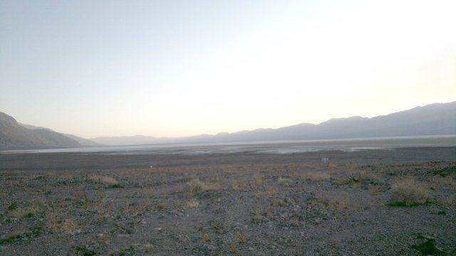
badwater basin, as seen from campsite near natural bridge
Sun, 4 Dec 2011 (45 miles)
Wind died down sometime in the night. Annoying Japanese tourists jammed their cameras in my face to take a photograph. Don't they have any manners? On the bus from Reno to Lone Pine, another passenger with a bike, who lived in Lone Pine and was returned from a tour in northern California, advised against Harry Wade road, on the grounds that it was too sandy. I ignored this advice and plowed ahead. Sure enough, after about a mile, the sand became too deep to pedal and I had to push the bike to continue making forward progress. But then the deep sand ended about a half-mile later and afterward the road was hardpack dirt. Perhaps because the deep sand stops most traffic, the road was also traffic-free thereafter, and not too washboarded. In looking back, this Harry Wade section was the best part of my entire Death Valley trip. Moral of story: even fellow bikers can't be trusted to give good advice. Derailleur had problems shifting to first. Tried adjusting limit screw, then realized chain was dried out from being covered with dust. Oiled it well, then it resumed shifting smoothly. Need to oil chain frequently in dusty areas, since dry dust is a potent degreaser. Camped just before Amargosa river crossing, about elevation 40'. River is normally dry/underground here but runs aboveground at Beatty.
along harry wade road, near amargosa dry river crossing
Mon, 5 Dec 2011 (39 miles)
Another short stretch of deep sand after the Amargosa River, maybe half a mile, where I had to dismount and push, but otherwise the road is hardpack with not too much washboarding. Pickup truck passed me in the morning, but no other traffic here on Harry Wade road. Sorry to leave it for paved highway 127, which has considerable truck traffic. But they give me wide berth, so it isn't too nerve-wracking. Stopped off at the Salt Creek Interpretive site to walk around and eat lunch. Camped about 13 miles north of Baker, at elevation 500'.
Tue, 6 Dec 2011 (29 miles)
Ice in bottles and bladder in morning. When I checked the weather report later, it said temperatures were 27°F last night. Supposedly, weather will be clear until next Tuesday, when there might be a chance of rain, with minimums around 32°F in Baker (which is at about 1000' elevation) and lower temperatures at higher elevations. No wind whatsoever today—very nice.
Lots of gas station convenience stores in Baker, with the usual assortment of junk food, plus two larger stores where highway 127 meets Baker boulevard. The Mexican store has fresh fruit, while the Country Market has Ben and Jerry's ice cream and a water tap on the side of the building. After gorging on fruit and junk food, I resupplied from the two stores and filled up my bladders. Both stores were low on wheat bread, but Mexican store had plenty of corn tortillas, and also plenty of cheese. In addition, I still had two loaves of wheat bread and cheese from Furnace creek and also several days of rice and peanuts from when I started this tour. So all in all, I left Baker with about 9 days food.
In addition to the spigot on the side of the Country Market store, there is water available in the restrooms at the town park (about a half-mile east on Baker boulevard, then turn north at the sign for the park—the park is about 100 yards from Baker boulevard). The building at the town park has outside electrical outlets, which I used to charge my cellphone. On the way into Baker, I passed an RV park that advertised laundromat and showers, but didn't investigate. Two motels in Baker, but they have terrible reviews on the internet. Anyway, I wasn't interested in a motel. Baker also has a post office, plus a huge number of fast food restaurants. I had two burritos at Del Taco myself.
After finishing up eating, catching up on news and email via my smartphone and resupplying, I crossed I-15 and headed into the Mojave National Preserve along Kelbaker Road, which has light traffic (cars every 5 to 10 minutes, which typically give me plenty of space). Campsite about 10 miles east of Baker on Kelbaker road, elevation 2000'.
campsite along kelbaker road
Wed, 7 Dec 2011 (25 miles)
Departed from Kelbaker road, which is paved, for the eastbound Mojave dirt road, where the two roads intersect. Reduced pressure in tires to 30 PSI (from 40 PSI originally) to better cope with soft sand. As long as I could keep speed up to 5 mph, bike stayed afloat and moved forward without much difficulty. But when I slowed down, it sunk into the sand and stalled, and I had to dismount and push until the road became hardpack again. I would estimate I was able to pedal about 90% of the time today.
Suspension fork is a liability in soft sand, in my opinion, as it interferes sensing the surface below the front tire, so as to know when the bike is about to stall, and the small amount of fork rake makes steering over-twitchy. In soft sand, the ideal is for the bike to handle like a supertanker—lots of forward inertia, hard to turn the front wheel. And obviously, the fatter and softer the tires, the better.
Cheese leaked some fluid. Should have stored it in a plastic sack inside one of the OPSaks, rather than just throwing it into the food sack and relying on the plastic manufacturer wrapper. This was Mexican-style soft white cheese. Fortunately, this sort of cheese is fairly odorless, so the mess in the food sack was easily cleaned up with paper towels. I won't be buying this type of cheese again, unless nothing else is available. In addition to leaking fluid, it is crumbly and tasteless and also part-skim and thus low-fat, whereas I want as much fat as possible now that cold weather is setting in.
Very peaceful here in Mojave National Preserve. Feels much less visited than Death Valley, especially away from the paved roads. Picked up a liter of water at Marl springs. Could have obtained more, but I'm still well-supplied and don't want to carry more weight than necessary. Siphon hose runs from an underground cave and the water looked, smelled and tasted okay, though there is always the possibility that some animal crawled down into that cave and died there.
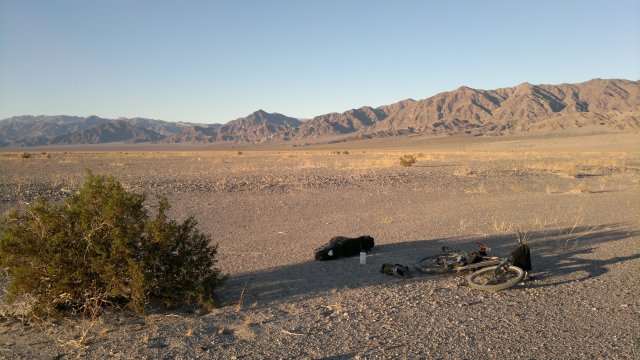
Wind picked up towards evening and it became quite cold after the sun went down. Decided to sleep with some of my water tonight. Campsite along Mojave Road, about 1 miles west of Kelso-Cima road, elevation 3600'.
Thu, 8 Dec 2011 (33 miles)
Water I left outside didn't freeze last night, but nevertheless I felt colder than on any night so far on this trip. Maybe the wind or maybe I'm not eating enough. While taking lunch, I looked at my overview map, and noticed the Sonoran desert (southwest Arizona) is at much lower elevation than the Mojave and thus will be considerably warmer. So maybe next year I'll start with the Mojave in late November like this year, then make my way down to the Sonoran desert as temperatures get colder. Fresh snow on the ground at elevations above 4500', up to 8" deep in gullies at 5000', and puddles in the road from melting snow. Visited Rock spring. Running slow, maybe 1 liter/min. No pool, like what is shown in the photos on the interpretive displays, just a thin stream on the ground and some ice from where the stream froze last night.
I've been alternating between National Geographic and Tom Harrison maps of the Mojave National Preserve. The Tom Harrison map is lighter in weight and one-sided and thus more convenient for getting an overview of the area, but it doesn't show all the minor dirt roads. So I would advise the National Geographic map if planning to travel the Mojave road, to speak nothing of the lesser known dirt roads. Main Mojave road is fairly well marked by cairns at intersections and forks. Campsite about a mile west of Piute Mountains on Mojave road, elevation 3400'.
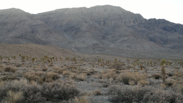
pinto mountain along mojave road, after cold night and snow at higher elevations
Fri, 9 Dec 2011 (40 miles)
Slept much warmer last night than the night before, possibly because I made sure to eat well before retiring, including a good portion of peanuts for fat and protein. Saw 2 bighorn sheep while descending from the pass over Piute Mountains. Very rugged road that was. I had to walk the bike much of the way due to the large rocks everywhere. Wind picked up again, from the north. I had to pedal into it for a few miles to get to Piute Springs road. Wind makes a big difference. Walked the bike up Piute Spring road, which is even more rugged than the road down from the pass. Water flowing in Piute Stream, just as the literature I'm carrying promised. Stream very overgrown with algae. Supposedly, the stream originates in a spring, about a mile further up the foot trail, but I didn't investigate. Canyon full of trees watered by stream. Passed a dozen or so 4x4 vehicles ascending Piute Springs road on my way back down. They were driving, I was pushing.
Decided to take highway 95 south rather than continue on the Mojave road to Laughlin. Maybe I'll visit there in the future, on my way to the Sonoran desert. The highway was downhill so I made very good time, but the riding is stressful. These trucks can't stop, because they are going downhill so fast, so I made a point of going onto the shoulder whenever they couldn't move to the other lane because it was occupied. I don't like being near motor vehicles period, but especially not big trucks.
Route 66 much more peaceful in terms of motor vehicles, but the trains on the BNSF railroad are very noisy. And based on the number of trains (like every 15 minutes, if you count both directions), a large percentage of the rail traffic to/from Los Angeles must travel on this set of rails. The trains going downhill blow their airhorn loudly, while the trains going uphill must run the locomotives at full speed and thus are loud for that reason. When it came time to camp, I walked the bike a half-mile or so down a sandy road south of Route 66, to try to get away from the noise. Unfortunately, sound travels only too well in the emptiness of the desert. Full moon tonight. Campsite a few miles east of Goff, at elevation 2300'.
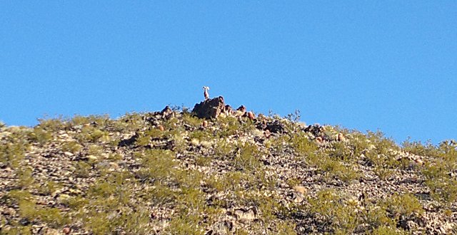
bighorn sheep in piute mountains (smartphone camera lacks long-range lens, hence the low-quality)
Sat, 10 Dec 2011 (38 miles)
Trains noisy all night long. Filled up up with water at the Goffs schoolhouse. Gates locked, but I spotted a spigot next to the gate, and crawled through the fence to access it. Spent some time admiring the outdoor museum that surrounds the schoolhouse. Decided not to go to Amboy. Route 66 is overrated. Only the 99.9% of bike tourists who eschew dirt roads, because they want to go fast and thereby get their tour over with as soon as possible, would think route 66 is better than the Mojave Road. Bought a fresh-made pastrami sandwich and some chips at the "Sahara Oasis" rest stop at the Fenner exit. The sandwich was good, as were the chips, but the store was very poorly stocked. Signs explaining that it cost a fortune to run a gas station/store in the middle of nowhere and therefore would customers please not complain to the cashiers about prices. Indeed they are in the middle of nowhere.
Turned off onto the Hidden Hill road just after this rest stop. Good to be back on dirt, and even better to be distancing myself from that noisy railroad. Road became sandy but still rideable, then was okay until Essex road, then the sand resumed. Eventually, I had to dismount and push the bike. After 3 miles of pushing, intersected with the dirt road shown running diagonally NE towards a water tank/corral, and the hardpack resumed. Weather report says light rain Monday and Tuesday, but mild weather otherwise. Double bowl of rice for dinner, to replenish carbohydrate stores after the long day of pushing through sand and then pedaling uphill. Camped near Hidden Hill mine, at elevation 3300'.
near hidden hill mine
Sun, 11 Dec 2011 (43 miles)
Sandwich and pie at Kelso Depot Cafe, plus loaded up on water at the spigot outside the exterior restroom building, which is thus available at all hours. Then several hours looking over the museum in the Depot.
Several options for where to go next. Option one is to take the Mojave road west towards Barstow. But I don't know the condition of that road. If very sandy, like the Hidden Hill road, then progress might be slow, so that I don't get across Soda Dry Lake before the rain starts tomorrow. Dry lakes can turn to slick mud when wet, and I don't want to pedal through that. Option two is to pass back through Baker, all the way to the powerline road which runs just north of Silver Dry Lake, and then follow that all the way to Barstow. Powerline roads are usually pretty good, according to the ranger. Option three is to return to Death Valley, cross the Panamint Range via the Warm Springs Canyon Road, then north through Panamint Valley to Lone Pine. In other words, bypass Barstow and Ridgecrest. But this option would require 5 days food, at a minimum. Postponed the decision until I reached the intersection of Kelbaker and Mojave roads, at which point my body made the decision for me and turned the bike onto the dirt. Touring on dirt is so much more enjoyable than pavement. Even if I have to push the bike now and then, or even push it frequently, I'd rather be on dirt.
I ran the tires at 30 PSI yesterday, then pumped back up to 36PSI when I reached Kelbaker this morning. 36 PSI is less than the 40 PSI I was using originally for pavement, but I didn't notice any slowdown. And 36 PSI also seems to work well on dirt. Since adjusting pressure is something of a nuisance, I decided to leave the tires permanently at 36 PSI from now on and see how that works.
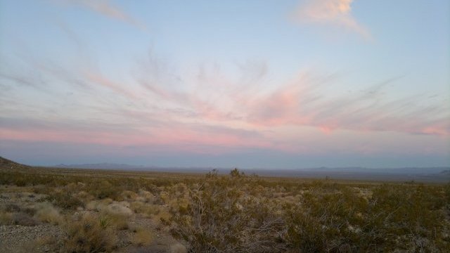
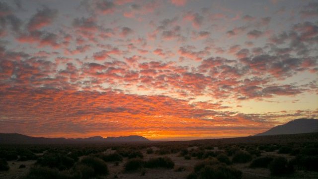
Camped along Mojave road, about a mile west of where it intersects Kelbaker road, elevation 2000'. Brilliant sunset, as it typical when rain is imminent.
multicolored sunset 1
multicolored sunset 2
Mon, 12 Dec 2011 (33 miles)
Made good time on Mojave road until it reached the Rasor OHV (off-highway-vehicle) area just west of Soda Dry Lake, where the road turned to sand. Decided to take Rasor road north, then cross I-15 and follow the road labeled Arrowhead Trail on the road atlas map, which evidently is also a powerline road. Turns out there was a gas station with very well-stocked convenience store at the Rasor road exit. Feasted on Ben and Jerry's ice cream, pistachio nuts, oatmeal raisin cookies, potato chips. Arrowhead trail was remnants of old paved road for a mile or so, then turned to hardpack, with occasional brief sandy sections. At Cave mountain, the road forks. One branch (not shown on the road atlas, but nevertheless a good dirt road) passes under I-15, following the powerline. The other branch continues on the north side of I-15, as shown on the road atlas map. But this northern branch must go up a very steep hill immediately after this fork. So steep I had trouble walking up. The road was evidently constructed by a bulldozer or similar earth-moving equipment, and is actually a pipeline road, and not really intended for ordinary vehicles, much less bikes. So I followed the powerline and crossed to the south of I-15.
Rain forecast was for 1/4" of rain starting sometime this afternoon. And sure enough, about 3PM, I began to feel drops of water on my arms. Quickly setup the bivy, making sure to position myself on high and gently sloping ground, away from any possibility of pooling or flash flooding.
Campsite was just before the powerline intersects Afton Canyon road, at elevation 1800'. As can be seen from the road atlas map, the powerline road at this point is separated from I-15 to the north by almost 2 miles of hills, and from the Union Pacific railroad to the south by another almost 2 miles from hills, and thus isolated from the noise of both. Thus this powerline road was clearly the better option.
just before rain begins
Tue, 13 Dec 2011 (43 miles)
Bivy protected me from the light rain last night, but at the cost of heavy condensation. Bivy is clearly only suitable for desert conditions, where rain is infrequent and the sun soon returns to allow drying things out. Bivy would be stifling in warm rain, and condensation would be a major problem where extended rain was possible (such as the Sierras). Followed the Afton Canyon road north to Dunn road, then followed that road (which consists of old broken pavement) all the way to Yermo. This old road is marked closed, presumably because it crosses a decrepit bridge at one point. But bicycles can easily get around the barriers. When you come to the decrepit bridge, descend to the sandy wash via a dirt road, cross the wash, ascend back to the pavement on the other side. Or take your chances and ride across the decrepit bridge. It might not hold a truck, but it will probably hold a bicycle.
Weather mostly clear during the morning, then light drizzle while I was stopped at the Burger Den in Yermo. They have a covered outdoor seating area, so I was able to stay dry. Forecast is for rain to stop this afternoon and for clear skies tomorrow and beyond. Rain today and yesterday was caused by arctic air moving in, so temperatures will be in 20's (Fahrenheit) at night from now, and possibly the teens at higher elevations.
Checked into the Motel 6 in Barstow ($44, including tax and wi-fi), then spent an hour or so cleaning grit off the bike. Noticed signs of rust on the fender holes on the rear rack. Miracle that the derailleurs still functioned, given how covered they were with grit. Will oil everything tomorrow, once the bike dries. Washed myself and clothes, then big food feast. Barstow at elevation 2000'.
dawn after rain
sun struggles to break through clouds
Wed, 14 Dec 2011 (43 miles)
Getting out of Barstow was a mess, as the 1st street bridge over the railroad tracks has only a very narrow space for pedestrians and bikes. If I ever come here again, I will try to cross the railroad tracks some other way. And the bridge over the Mojave river wash looked even worse, so I simply pushed the bike over the wash (too sandy to pedal) to Fort Irwin road on the other side. After that, not too much traffic, and then no traffic after I turned off on Fossil Bed dirt road. Noticed lots of birds singing, and more than the usual number of rodents running about, perhaps because of the recent rain. Ground is quite moist.
Nokia N8 smartphone proved very useful, because the road atlas paper maps do not show the full network of dirt roads on the ground, and these dirt roads are not signed at intersections and forks. So I would advise carrying a mapping GPS for travel on dirt roads in this area, if the road atlas is your only paper map, or else a smartphone like the N8, which is equivalent to a mapping GPS. By contrast, the National Geographic maps for Death Valley and Mojave National Preserve showed most of the dirt road network, and in the few cases where they didn't, I was able to use the GPS grid on the map, together with my wilderness GPS, to determine which was the correct road to take at intersections and forks, or to get back on track if I somehow took a wrong turn. My wilderness GPS (Garmin Foretrex 301) allows setting map datum and then shows exact location in the selected coordinate system (lat/long, UTM, British national grid, etc), whereas the Nokia N8 presumably always uses WGS84 datum and either doesn't show coordinates or else only shows lat/long. So the N8 is not really suitable for wilderness bushwhacking (lack of water-resistance, limited battery life, lower tolerance for being dropped or otherwise subjected to shocks than the Garmin device are additional issues with relying on the N8 for wilderness usage). But that is not an issue with a bike, since I plan to remain on roads, and the N8 has a fairly complete map of those. Even when I did stray off-road (such as when crossing a dry lake, where the road disappeared), the N8 showed both my location and that of the road I had strayed from, so that it was easy to get back on-road.
Since the road atlas maps have a basic lat/long grid (NAD83 datum) and show crude topography via sketching mountainous areas, the wilderness GPS could be used with these maps as follows. 2 miles on a 1:300K scale map is just under half an inch. Thus by taking a fix a half-hour or so after a fork or intersection where there was some question about direction to take, it should be possible to eyeball the map versus location shown on the wilderness GPS device to determine if off-course. Since there is no risk of going in circles when backtracking on roads (compare with cross-country travel by foot in densely forested areas), getting lost is impossible. So a mapping GPS isn't required, but it will save time.
If used sparingly, the N8 battery will last at least a week. So far, I've kept the phone turned off except when taking photos. When I do turn it on out here in the backcountry, I use offline mode, since there is no network available, and that further reduces battery usage. Offline mode means that location is obtained solely from GPS satellite data, rather than using the cellphone network to determine location via triangulation. Finding location from GPS satellites is slower than using the cellphone network, but that is a moot point when there is no cellphone network available. My N8 came preloaded with maps for the United States. Maps for most of the rest of the world are available for free for download and downloading is very easy: just select, using the mapping application, the countries for which you want maps, and then wait as they download (maps are fairly large, so best to download using wi-fi). Device has 16GB internal memory, which more than enough for maps of the entire world, and capacity can be expanded via microSD cards. Make sure to download maps BEFORE heading into the backcountry.
This area north of Barstow is even more empty than Mojave National Preserve, which in turn was emptier than much of Death Valley National Park. Though all three are wonderful for those seeking desert solitude. Camped along Hoffman Road, about 2miles east of Cuddeback Dry Lake, elevation 2600'.
rainbow basin, multicolored hills
Thu, 15 Dec 2011 (35 miles)
Very cold morning, under 20°F. Frosted dew on everything. Water okay because I used the only bladder with water in it as a pillow and kept the bottle next to my body. Not shown on road atlas map, but just before Hoffman Road hits highway 395, there is a dirt pipeline road labeled Jo-burg/Randburg Gas. This dirt road runs parallel to and about a half-mile east of 395 until it reaches Trona Road, at the point where Trona Road meets 395. If going the other direction, this dirt road is labeled Cuddeback road. So by taking this road, I was able to avoid 395 entirely. Continue north along Trona road to the the Wagon Wheel OHV (off-highway-vehicle) staging area, shown on the road atlas map and also indicated by BLM signs. The staging area is east of Trona Road. Right across Trona road is a dirt road, which leads about 7 miles west to Ridgecrest. Arrived at the Ridgecrest Motel 6 ($40 incl tax) at about 1PM. Ridgecrest is at elevation 2200'.
dawn after frigid night
Fri, 16 Dec 2011 (0 miles)
Decided to spend an extra night in Ridgecrest, because the weather forecast is for strong winds (up to 40mph) from the north today (headwind for me). Visited T J Frisbees bike shop, which the other bicyclist on the Reno to Lone Pine bus had highly recommended. I briefly talked to some workers there and it is obviously a highly competent bike shop. And there are good reviews on the internet. So this is the probably the best place for someone in the Mojave desert area to get serious bike work done. Bought some spare brake pads, since I had used the spares I started with to replace the front pads, which kept tilting out of alignment. I should have replaced these front pads before I started the trip, since they've been acting up since I first bought the bike. Should have little difficulty making it 132 miles from here to Lone Pine via Panamint Valley in 3 days, so made a CREST reservation for Tuesday. Reservations aren't required, but they are recommended, especially if transporting a bike, since the bike rack on the front of the bus only has room for 2 bikes.
AT&T started charging me for data usage yesterday. When I inquired, they said my data balance was at zero. But I don't see how that is possible. It took several months to even use up 200MB, and yet I started this trip with 400MB, so that means I used 400MB in just a month, despite not using the internet frequently while traveling. All my usage at Beatty was over wi-fi. I think AT&T somehow just zeroed out my data balance. Hard to prove it, given how stupid the service representatives are. Maybe they are trained to act stupid. Gave up and bought another 10MB and I'll investigate further when I get back.
Sat, 17 Dec 2011 (50 miles)
Made excellent time to Trona, where I took a rest stop, but then the wind started. Wind combined with uphill slope made for very hard pedaling. Gave up and pushed the bike several miles to Slate Range Crossing. Frightening descent on the other side: unable to hear cars from behind due to the noisy wind (thank God only three cars did pass from behind), bike being pushed around from lane to lane, bike shimmying even though my speed was only 10mph. Very nerve-wracking. Once the descent ended and I reached level ground, forward progress into the wind became very difficult. Gave up and called it a day about 3PM, though my original intention was to try to make another 15 miles today, so as to reach Lone Pine tomorrow and take the CREST bus Monday, assuming they have space. So now I'll just have to go with my original plan of reaching Lone Pine Tuesday. Clouds over the mountains, but mostly clear overhead here in the valley, but that might change in the night, so I prepared for rain. Campsite in the middle of Panamint Valley, elevation 1100'.
panamint mountains, from my campsite in panamint valley
Sun, 18 Dec 2011 (71 miles, 1139 ending odometer)
Warm last night due to low elevation, maybe 45°F. Very light drizzle during the night, just a few drops. Partially closed the bivy. No condensation in the morning. No wind either, but lots of clouds. Gas station in Panamint Springs very poorly stocked. Just a few snacks and cold drinks. Ate a big cookie and liter of Gatorade, then began the long ascent out of Panamint Valley. pedaled the first 1000' of ascent (which took about 30 minutes), then walked the next 1000' (which took about an hour), then resumed pedaling (another 1000' or so of ascent, but not so steep as before). Made better time than I was expecting, and so decided to shoot for Lone Pine today after all. Arrived at Dow Villa at 3:30PM (room with ensuite bath for $67 incl tax). Since I started at 7:30AM, took about an hour of rest stops, and rode 71 miles today, average speed was 10 miles/hour. Not bad, considering my speed during the hour pushing the bike uphill was about 3mph. The final downhill stretch I probably averaged 15mph. Lone Pine at elevation 3700'. 71 miles.
Mon, 19 Dec 2011
Took the CREST bus back to Reno ($60), and canceled the reservation for tomorrow.
Statistics
27 days total, of which 6 nights in motels, 21 night camping, of which 2 nights with light rain, 2 nights with dew (actually, frost or frozen dew in both cases). 2 zero-mileage days, thus 25 days traveling.
853 miles total. Thus, for 25 days of traveling, average of 34 miles/day.
Last trip for year 2011, and thus time to collect yearly statistics. Total of 101 nights traveling, 85 nights camping.
Comments
- Tore my right pants leg on the large chainring, and I've caught it on the large chainring numerous times. I considered sewing a velcro strap to my pants, so I wouldn't have to roll them up or tuck them into my boots. The problem is that I still have to remember to attach the strap, and all it takes is one memory failure to risk tearing my pants. Thus a chainguard of some sort would be a wise addition, at least with a standard derailleur setup with multiple chainrings. I'm not sure if the single chainring on the Thorn Nomad that I plan to order will pose the same risk of tearing pants. With a single chainring, the chain is always on the ring, so the pants can only be caught between chain and ring. Saleswoman says chainguard on the Nomad adds 115 grams. Don't see many other Nomads with chainguards.
- Need a plastic sack for storing the instant rice, not just a silnylon food sack. I was thinking that the desert is mostly dry, and the Ortlieb panniers are waterproof, so no need to protect the rice. But I didn't consider that I would be storing bladders in the panniers along with the rice, and the bladders might be wet on the outside from water spilled while filling the bladder. Also, the panniers might be waterproof when new but then later develop a leak. So the rice needs to be protected from moisture inside the pannier. Not necessarily with an OPSak, though that is an option.
- Consider bringing along a fourth bladder as a spare on long tours. There is equipment that continues to function when damaged, such as pants with a torn leg from getting caught in the chainring, and equipment that either works or doesn't work. A bladder that leaks even slightly doesn't work, and there is no way to replace bladders while touring, other than by ordering by internet and then waiting around in a motel for several days for the order to arrive.
- Front suspension and front racks/panniers are both undesirable for desert travel where sand may be encountered. The front needs to be lightly loaded so that it will rise up rather than bogging down in the sand. And front suspension makes steering fiddly so that it is difficult to keep the bike moving forwards along the narrow line of sand compressed by previous motor vehicle travel.
- Road atlas does not show the full network of dirt roads. So mapping GPS of some sort is necessary, unless you don't mind backtracking if a wrong turn is made.
- Nokia N8 worked very well for all its intended functions: voice communications; camera; email; internet browsing; mapping GPS with onboard maps so that network access is not required; e-reader for personal documents (including these hiking/biking notes). Best of all, it performed all these functions without even coming close to draining the battery, assuming I kept the phone turned off most of the time. As I recall, battery charge level never dropped below 75%.
- Bike computer was also very useful. Because this is something that can fail (lost magnet, broken wire, dead battery, broken computer), consider bringing a spare, including plastic ties for attaching to handlebars.
- Mirror is not merely useful but essential for safety on highways. Given the stress on the mirror from laying the bike on its side during rest stops or from bumping into objects on the left of the bike, bringing along a spare of this accessory is also advisable.
- Pannier hooks rubbed away paint on Thorn racks within a few days, exposing bare metal. However, since they rub continuously, no rust develops. Other parts of the rack (bolt holes for fenders, in particular) do show signs of rust.
- I didn't consider that stans sealant can leak out in certain situations. So carry 6 bottles next time, rather than just 2.
- Best to bring two bottles of chain lube on long desert trips, though I didn't even use up even a single bottle on this trip. Chain lube is essential in the desert, due to the drying effect of dust.
- Hiking boots and platform pedals are recommended, due to the need to get off the bike and push through sandy or rocky sections. Anyone planning to wear biking shoes should first try walking 10 miles through desert terrain in these shoes to see how well they work and last under such usage. Toe clips are extremely inadvisable. When the bike stalls in sand, as it does frequently in the desert, you will be thrown violently forwards. If using regular shoes and platform pedals (and assuming there is adequate standover clearance), your feet simply slide off the pedals and you land solidly on both feet. Toe clips would be a disaster and it will take quick thinking to get your feet free with cleats.
- CREST bus only has two spaces in the bike rack on the front of the bus. Problem for groups of bikers.